
Is A Tropical Depression In Wisconsin Weird? - Yes
Marshall Shepherd, Forbes,
At this point, 2020 is proving to be a year that can give the best episode of the Twilight Zone or X-Files a run for their money. The weather world is no different. Tropical Storm Cristobal recently became the earliest “C” storm on record. My Forbes colleague Dennis Mersereau also documented the flooding associated with the storm as it moved inland. However, Cristobal was not done. Earlier this week, Cristobal was still a Tropical Depression as it traversed the state of Wisconsin and as a post-tropical system, it is moving into Canada. Is that weird?
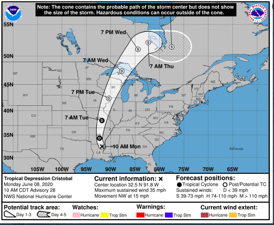
Well, the short answer is yes. WSB meteorologist Kirk Mellish provides some useful context. Mellish wrote, “Cristobal still a TD in WI yesterday officially the most NW track of any in history. Spun up tornadoes near Chicago.” Meteorologists were stunned to see a National Hurricane Center forecast map (above) with a Tropical Depression in Wisconsin, and remnants of the storm crossing the Great Lakes into Canada. The Cooperative Institute for Meteorological Satellite Studies. (CIMSS) is based at the University of Wisconsin. They provided some outstanding historical context on their Facebook page. They wrote, “Historical data reveals Wisconsin has never had a system that has been classified as 'tropical' move through the state, tonight could be the first.”
Most Popular In: Science
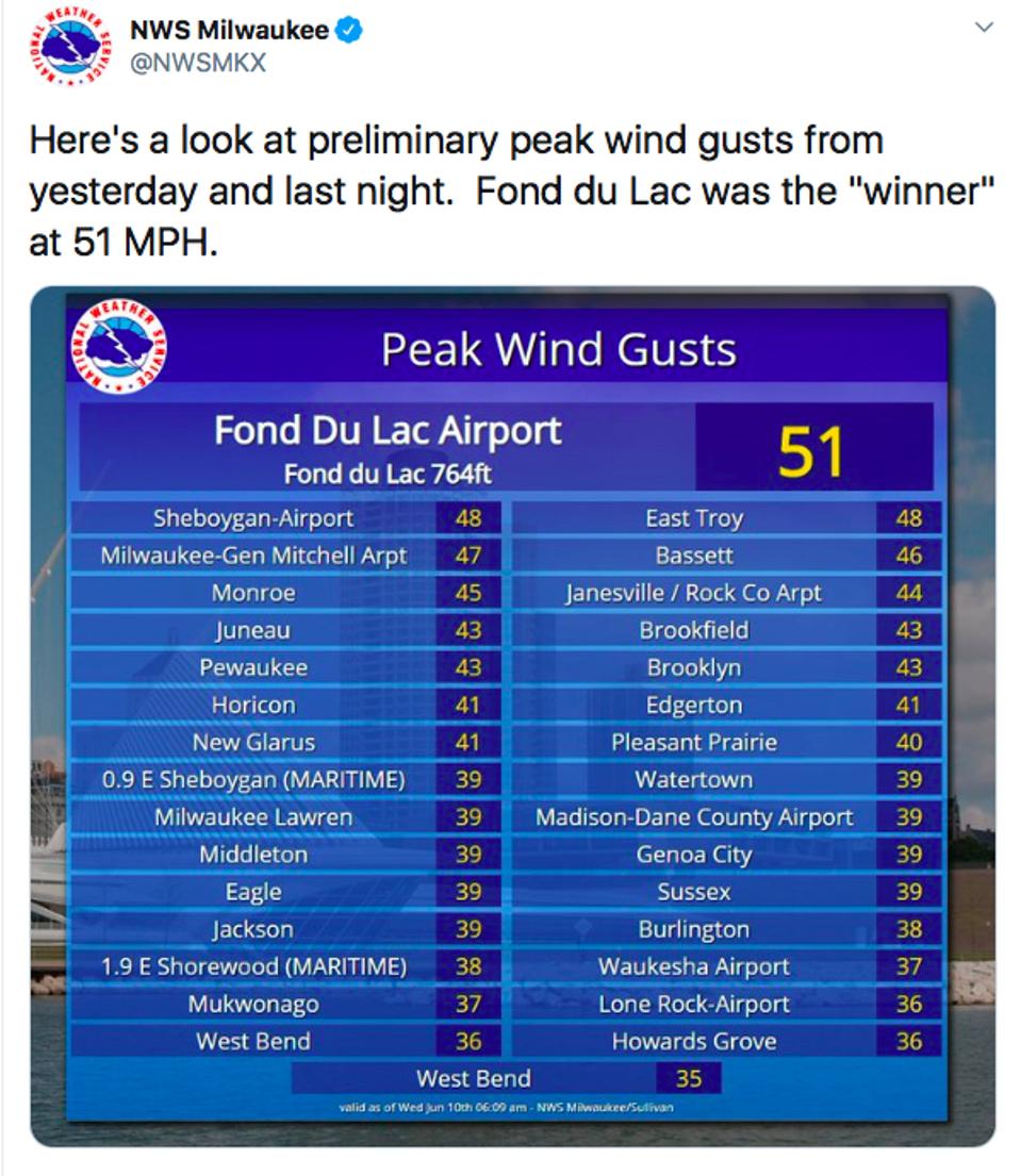
As fascinating as that factoid is, they also note that it is even rare to have a post-tropical system to move through Wisconsin. According to CIMSS, three post-tropical systems (1886, 1900, and 1949) had portions of their circulation impact the state. With such a rare event, records were bound to be broken. According to the National Weather Service - Milwaukee, the city of Madison broke its record for lowest pressure ever recorded in June (988.0 mb or 29.20 inches), a record that held since 1936. The office also noted many peak wind gusts in the 40-50 mph range with Fond du Lac topping out at 51 mph.
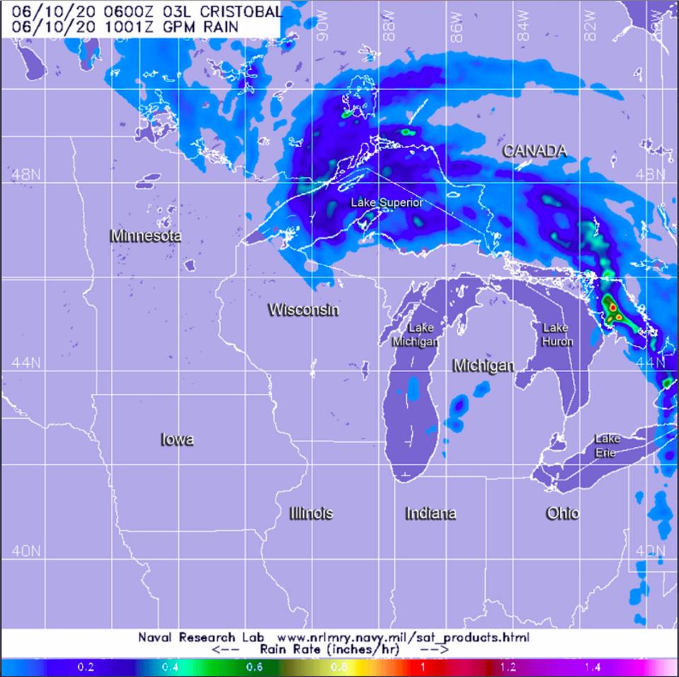
According to a NASA website, “At 5 a.m. EDT (0900 UTC) on June 10, the center of Post-Tropical Cyclone Cristobal was located near latitude 45.8 degrees north and longitude 88.2 degrees west.” This almost 200 miles north-northeast of Madison, Wisconsin. It is bizarre that I am writing about a Post-Tropical system making its way into Ontario, Canada. NASA’s Global Precipitation Measurement (GPM) Mission, of which I served as Deputy Project Scientist during my tenure at NASA, shows some of the rainfall characteristics of this historic storm (graphic below).
It’s 2020 y’all. What else is in store?

Dr. J. Marshall Shepherd, a leading international expert in weather and climate, was the 2013 President of American Meteorological Society (AMS) and is Director of the
…
No comments:
Post a Comment