Showing posts with label global warming. Show all posts

Thursday, February 27, 2025

CLIMATE CHANGE: Alaska's ice is melting in front of our eyes, staggering satellite shots show

 Climate change and global warming have been changing the Earth more quickly since the Industrial Revolution. It's a fact. Pollutants are speeding up a changing world climate, and warming it, which is creating extremes (from polar vortex outbreaks to more droughts and floods). Visual proof is seen in these satellite images of Alaska, taken from NASA satellites.  Here's the story.

Caption: NASA satellite image showing melt in Alaska. (Image credit: NASA Earth Observatory/Wanmei Liang)


Alaska's ice is melting in front of our eyes, staggering satellite shots show 
 By Ben Turner, LIVE SCIENCE  February 7, 2025

Unusual weather patterns and climate change have been driving stark changes in the northwestern state. Now, new satellite images show the extent of this transformation.

 New satellite images reveal the stark pace of global warming in Alaska, with last year's snow vanishing and leaving behind miles of bare ground.

The images, taken by the Moderate Resolution Imaging Spectroradiometer (MODIS) instrument on NASA's Terra and Aqua satellites, show Bristol Bay Borough in southern Alaska. Anchorage, which is located to the northeast, had an average January snow depth of 13 inches (33 centimeters) between 1998 and 2025.

But this year, the station, alongside other parts of the state, reported next to no snow on the ground. What is left behind are large patches of ground visible from space.

"Since December 2024, temperatures across the state have been 5 to 10 degrees Fahrenheit (3 to 6 degrees Celsius) above normal, according to NOAA, and isolated areas have experienced even greater anomalies," NASA Earth Observatory wrote in a blog post accompanying the new images. "The warm temperatures caused existing snow and ice to melt and new precipitation to fall as rain."

As climate change heats up the planet, Arctic regions such as Alaska are experiencing dramatic rates of warming, with temperatures increasing up to four times faster than the rest of the world. Anchorage's average temperature was 29.3 F (minus 1.5 C) in January — 13 F (7.2 C) above average and warmer than readings taken in three dozen other states.

The reasons for this are twofold. First, unusual weather conditions across the North Pacific fueled a marine heatwave across North America this winter. This warming was worsened in Alaska thanks to a warm, high-pressure ridge of air hanging over the state.

Wednesday, September 27, 2023

SCIENCE: Record highs at sea and on land, and a ‘shocking’ decline in Antarctic ice

 I've been studying climate change for decades, and have seen a lot of changes. Winters in the northeastern U.S. are nowhere near as snow-filled as they used to be 30-40 years ago. Crepe Myrtle trees which never grew in Maryland because it was too cold in the 1960s, 70s and 80s, now thrive.  Sharks are now common off the coast of southern New England because of the warmer waters. The boreal (northern) forests have been pulling further north over the last 20 years. Today's blog contains highlights from a World Meteorological Society report about more warming effects this year! 

(Photo: the sun on a scorching summer day. Credit: KRIS-TV)

Record highs at sea and on land, and a ‘shocking’ decline in Antarctic ice 

  EARTHSKY, Deborah Byrd, July 11, 2023

The World Meteorological Organization (WMO) held an impromptu televised press conference on July 10, 2023 to answer questions and to confirm a series of announcements about record highs temps on land and at sea. There's also been a record decline in Antarctic sea ice. The scientists said the first week of July 2023 was the warmest week yet recorded. They said global sea surface temperatures were at a record high in May and June 2023. They called the decline in Antarctic sea ice "shocking." And they said these developments were "… of great concern to the scientific community and indeed to everybody.

Omar Baddour, Chief of Climate Monitoring at WMO, and Michael Sparrow, Chief World Climate Research Program with a specialization in Antarctica, led the press event.

These scientists said that the first week of July 2023 was the warmest week yet recorded. They said global sea surface temperatures were at a record high in May and June 2023. They spelled out the amount of decline in Antarctic sea ice.

‘We’re in uncharted territory’

El Niño is characterized by a warming of the Pacific Ocean. The WMO said that – combined with human-induced climate warming – the weather pattern is expected to hike up global temperatures. The WMO officials told journalists in Geneva today that impacts can be expected to extend into 2024 and beyond.

(Image: Land surface temperatures from NASA's Aqua satellite on July 10, 2023. Orange represents the hottest areas. Credit: NASA Worldview)

Just Getting Started with the Warmth This Year

During an El Niño year, you get higher temperatures in the atmosphere as well because heat is moving from the oceans to the atmosphere.

We are actually at the beginning of that process, so El Niño hasn’t had as much of an effect as it is going to later in the year. So, we’re seeing these high temperatures in the North Atlantic…despite the fact that El Niño hasn’t really got going yet.

‘Shocking’ decline in Antarctic sea ice

Meanwhile Antarctic sea ice levels reached their lowest extent for June since satellite observations began. They are a “shocking” 17 per cent below average. An article at UN News reported: … this year’s readings broke the June 2022 record by a substantial margin and represented ‘a really dramatic drop in the sea ice extent in the Antarctica’ – some 2.6 million square kilometers of lost sea ice.

Impact on fisheries

Beyond Antarctica, the WMO warned that the high sea surface temps would also impact fisheries distribution and ocean ecosystems, as well as inland: It is not only the surface temperature of the water, but the whole ocean is becoming warmer and absorbing energy that will remain there for hundreds of years. 

(MY NOTE: Southern waters can get too warm for some fish that would migrate north, and northern waters would be warm enough to have them thrive. Fishermen off the coast of California have noticed that now). 

Friday, June 2, 2023

Climate Warming Proof Around the World: 2023

Here are a collection of research articles about how the warming worldwide climate has been affecting different parts of the world. From increased Greenland ice melting, warming oceans, and sea level rise to drought-stricken areas like Spain and the U.S. Southwest. In 2021, U.S. Pacific Northwest endured its hottest year in 1000 years. Today's blog is a collection of stories showing what the warming climate has been doing around the world. 


Image: The Sau Reservoir in Spain dropped to 7% of its capacity in April. Fred Pleitgen/CNN

Disappearing Lakes, Dead Crops and Trucked-in Water: Drought-stricken Spain Is Running Dry

Spain has been in a long-term drought since the end of 2022, with the country receiving only 36% of the average monthly rainfall in March and the trend continuing into April.

Drought Spells Catastrophe for Spain's Olive Harvest

CNN - May 9, 2023 - MADRID: An ongoing drought and soaring temperatures have unleashed fears of an olive "catastrophe" in Spain, the world's largest producer of olive oil, which suffered a very difficult year in 2022.

"It's barely rained since January. The ground is very dry," worries Cristobal Cano, secretary general of the small farmers' union (UPA) in the southern region of Andalusia, the heart of Spain's olive oil industry.

(Image: Long term trend of global ocean water temperatures is on the increase.   Credit: 

Why Are Our Oceans Getting Warmer?

National Geographic - 1 May 2023

The temperatures of the world’s oceans are hitting record highs, with far-reaching consequences for marine life, storm intensity, and sea levels.


NASA: The effects of ocean warming include sea level rise due to thermal expansion, coral bleaching, accelerated melting of Earth's major ice sheets, intensified hurricanes*, and changes in ocean health and biochemistry.

(Image:  June 26, 2021: Temperatures in the Pacific Northwest will skyrocket in the coming days as a heatwave sets in from Southern California to Northern Washington. The high-pressure system is expected to break record temperatures. National Weather Service) 


In the Pacific Northwest, 2021 Was the Hottest Year in a Millennium

Eos - 2 May 2023

A 1,000-year temperature record shows unprecedented warming in the Pacific Northwest, and new modeling predicts the likelihood of future heat waves in the decades to come.  


OREGON ENCYCLOPEDIA -During the 2021 event, Portland International Airport exceeded 100°F for three consecutive days—108°F on June 26, 112°F on June 27, and 116°F on June 28. The previous record high at the airport was 107°F, making June 28 a remarkable nine degrees warmer.


Prolonged Droughts Likely Spelled the End for Indus Megacities

Science - 26 April 2023

New research has found evidence—locked into an ancient stalagmite from a cave in the Himalayas—of a series of severe and lengthy droughts that may have upturned the Bronze Age Indus Civilization.


(Image: There has been a gradual warming of the deep basin bottom water at a rate of 0.017 °C each year from 2005 to 2015. Credit: Göran Ingman / Flickr There has been a gradual warming of the deep basin bottom water at a rate of 0.017 °C each year from 2005 to 2015. Credit: Göran Ingman / Flickr)


Atmospheric Rivers Linked to Melting Greenland Ice Sheet

University of Wisconsin—Madison - 3 May 2023

Atmospheric rivers are a key factor in the complex conditions accelerating glacial melting over northern Greenland, according to a new study.

 Study: Sinking Ground in Parts of Chesapeake Bay Area Will Worsen Flooding From Rising Sea Levels and Storm Surges

Using radar imaging to measure elevation changes, researchers have uncovered an important gap in planning for sea level rise in the Chesapeake Bay: in some areas, sea levels are rising at a faster rate than previously thought because the land is sinking.


Thursday, February 10, 2022

Lots Record-Breaking Temperatures Around the World Over Last 2 Years

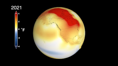
 On January 13, 2022 a coastal city in northwestern Australia recorded the hottest ever temperature it had ever seen. 123 degrees Fahrenheit (It tied one other event).A station in Onslow, a small coastal town in Western Australia, registered a sweltering 123.3 degrees (50.7 degrees Celsius) amid a severe heat wave. If verified, it would tie the all-time high reading set in Oodnadatta, Australia, on Jan. 2, 1960. In Mid-January, NASA and NOAA released their Annual Global Temperature analysis and determined that 2021 was tied for the 6th Warmest Year on the planet. (CLICK FOR THE RESEARCH) 


(image: This data visualization shows global surface temperature anomalies for 2021. Higher than normal temperatures, shown in red, can be seen in regions such as the Arctic. Lower than normal temperatures are shown in blue. Credits: NASA’s Scientific Visualization Studio/Lori Perkins)

Courtesy of NOAA and the World Meteorological Organization, from the Washington Post, here is a select list of verified and unverified national and international record-breaking temperatures (in recorded history) in the past two years:

  • World’s hottest year at 1.08 degrees (0.6 degrees Celsius) warmer than 1981-2010 average: 2020 tied with 2016
  • World’s hottest month at 1.67 degrees (0.93 degrees Celsius) above the 20th-century average: July 2021
  • World’s highest (and North America’s highest) reliable temperature at 129.9 degrees (54.4 degrees Celsius), at least since 1931: Death Valley, Calif., Aug. 16, 2020, and July 9, 2021
  • Arctic’s highest temperature at 100.4 degrees Fahrenheit(38 degrees Celsius): Verkhoyansk, Russia, June 20, 2020.
  • Antarctica’s coldest season with an average of minus-78 degrees Fahrenheit (minus-61 Celsius): 2021
  • Europe’s highest temperature at 119.8 degrees Fahrenheit (48.8 degrees Celsius): Syracuse, Italy, Aug. 11, 2021
  • Canada’s highest temperature at 121 degrees Fahrenheit (49.6 degrees Celsius): Lytton, B.C., June 29, 2021
  • Turkey’s highest temperature at 120.4 degrees Fahrenheit (49.1 degrees Celsius): Cizre, July 20, 2021
  • Spain’s highest temperature at 117 degrees Fahrenheit (47.4 degrees Celsius): Montoro, Aug. 14, 2021
  • Greece’s highest temperature at 115.3 degrees Fahrenheit (46.3 degrees Celsius): Makrakomi, Aug. 2, 2021
  • Paraguay’s highest temperature at 113.9 degrees Fahrenheit (45.5 degrees Celsius): Pozo Hondo, Sept. 26, 2020
  • Oman’s highest temperature at 124.9 degrees Fahrenheit (51.6 degrees Celsius): Joba, June 16, 2021
  • United Arab Emirates tied highest temperature at 125.2 degrees Fahrenheit (51.8 degrees Celsius): Sweihan, June 6, 2021
  • Iraq’s highest temperature at 125.2 degrees Fahrenheit (51.8 degrees Celsius): Baghdad, July 28, 2020
  • Cuba’s highest temperature at 102.7 degrees Fahrenheit (39.3 degrees Celsius): Veguitas, Aug. 11, 2020
  • Ghana’s highest temperature at 111.2 degrees Fahrenheit (44 degrees Celsius): Navrongo, April 6, 2020
  • Lebanon’s highest temperature at 113.7 degrees Fahrenheit (45.4 degrees Celsius): Houche Al Oumara, July 27, 2020
  • Contiguous United States’ warmest December with an average of 39.3 degrees Fahrenheit (4 degrees Celsius): 2021
  • NASA VIDEO: https://youtu.be/pLU8v8fAw7s

Friday, September 10, 2021

Increase in Flooding Events Around the World (6 Videos of Diff. Places)

 If you haven't been keeping track of major flooding disasters around the world, here are a few videos of them from Mexico; Spain; New York City, US; North Korea; London, England; and China. A warmer world holds more moisture in the atmosphere, leading to storms that generate more and heavier rainfall. Look at these big flood events around the world in the last couple of months. Videos are all from BBC News.

On September 7th, in central Mexico, northeast of Mexico City- Heavy rainfall in central Mexico has sparked flash floods in Ecatepec and Nezahualcóyotl municipalities, sweeping away vehicles and turning this street into a river. On September 3rd, A state of emergency has been declared in New York after it was hit by record rainfall and deadly flash floods as a result of Tropical Storm Ida.Videos showed floodwater pouring into a subway station, as well as passengers on a flooded bus and cars being swept away.  


(Image: The GeoEye-1 satellite captured this image of flooding in New Brunswick, New Jersey, on Sept. 2, 2021 from the remnants of Tropical Storm Ida). (Image credit: Satellite image ©2021 Maxar Technologies/LIVESCIENCE)

 On September 2nd, northeast of Barcelona, Spain - Thousands of homes are without electricity, and roads and rail links have been forced to close. Coastal towns in the north-eastern region of Catalonia bore the brunt of the storm, as well as parts of central Spain near Madrid. 

 VIDEO:  

 On August 8th, The east of North Korea was struck by severe flooding after heavy rain, leading to homes being destroyed and thousands of people being evacuated. The state broadcaster said some regions had seen over 50cm (20in) of rain in three days.

On July 25, Flash flooding after heavy rain sweeps across London / Flash flooding after heavy rain sweeps across London Close. The fire brigade said it had taken about 300 calls - mostly about flooded basements or roads - on Sunday afternoon. Officials have advised against travelling in the hazardous conditions. An amber thunderstorm warning is in place for much of south-east England, with 75 to 100mm (3in to 4in) of rainfall forecast in some areas. On July 22, drone footage captured the scale of floods in China's Henan province, showing stranded cars and a highway still substantially under water. And as aerial pictures show the extent of damage, BBC China correspondent Robin Brant reports on the situation on the ground in the city of Zhengzhou

.

Friday, August 27, 2021

Simply Explained: Why Weather is Becoming More Extreme

Over the last week, I highlighted the new report from the International Panel on Climate Change (IPCC) that presented alarming findings about how we humans, have exacerbated the warming of the Earth and seriously affecting climate change. Here's a great article from the VERGE that interviewed a scientist at NASA. The article puts everything in easy-to-understand terms, and is a MUST-READ..

(Image: This graph illustrates the change in global surface temperature relative to 1951-1980 average temperatures, with the year 2020 tying with 2016 for warmest on record (Source: NASA's Goddard Institute for Space Studies). Learn more about global surface temperature here. Credit: NASA/JPL-Caltech) 

WHY THE WEATHER IS BECOMING MORE EXTREME 

We’re headed into ‘uncharted territory’

By Justine Calma@justcalma  The Verge  Aug 10, 2021, 10:30am EDT

Across China and Western Europe in July, the amount of rain that might typically fall over several months to a year came down within a matter of days, triggering floods that swept entire homes off their foundations. In June, the usually mild regions of Southwest Canada and the US’s Pacific Northwest saw temperatures that rivaled highs in California’s Death Valley desert. The severe heat was enough to buckle roads and melt power cables.

HUMANS ARE FUELING MORE DANGEROUS WEATHER

This month, a landmark United Nations report helped put those kinds of extreme events into context. By burning fossil fuels and releasing planet-heating greenhouse gases into the atmosphere, humans are fueling more dangerous weather. Researchers have been able to connect the dots between greenhouse gas emissions and climate change for decades. But the new report showcases a big leap forward in climate science: being able to tie the climate crisis directly to extreme weather events like the June heatwave, which would have been “virtually impossible” without climate change according to recent studies.

The Verge spoke with Alex Ruane, one of the authors of the new report and a research physical scientist at the NASA Goddard Institute for Space Studies. He walks us through the phenomena that’s supercharging extreme weather events. And he explains why scientists have gotten so much better at seeing the “human footprint” in each weather disaster.

(Image right: High-tide flooding in Honolulu.  Credits: Hawaii Sea Grant King Tides Project) 

The new United Nations report ties many changes in extreme weather to a more intense water cycle. 

What is the water cycle and how does it affect the weather?

The water cycle is basically the way that we track moisture moving through the climate system. So it includes everything from the oceans to the atmosphere, the clouds, ice, rivers, lakes, the groundwater, and the way that those things move and transfer moisture and water from place to place.

(Image: Forest fires in Turkey. Credit: NASA) 


WHAT HAPPENS WITH AN INTENSIFIED WATER CYCLE?

So when we’re talking about the intensification of the water cycle, we’re basically saying things are moving faster. Air is pulling the moisture out of the oceans and out of the land faster. It’s moving more moisture from place to place on the planet. And when it rains, it can come down hard.

The fundamental difference is that there is more energy in the system. There’s more heat. And as the temperature goes up, there is an overall increase in the amount of moisture that the air is trying to hold. So that means when a storm happens, there’s more moisture in the air to tap into for a big, heavy downpour. It also means that when air moves over a region, it has the potential to suck more moisture out of the ground more rapidly. So the same phenomenon is leading both to more intensive rainfalls and floods and precipitation, and also to more stark drought conditions when they do occur.

How are people affected by those changes?

So, I personally live in New York City. We are affected by the water cycle, for example, when there’s a heavy downpour it can flood subway stations. It can lead to surface flooding in rivers and streets that can affect transportation.

(Image right: The images compare pictures of California's Shasta Lake and Lake Oroville captured in 2021 and in June 2019, during more typical conditions. The pictures taken this year show significant tan fringes around the water, a phenomenon known as “bathtub ring,” as the water level for both reservoirs has decreased dramatically as snow melted away a month ahead of schedule. Credit: NASA) 

Other parts of the world have different engagements with the water cycle. They may be concerned about the snow fall or river floods that affect broad areas. And then of course huge parts of the world are concerned about drought. When we look at something like drought, it doesn’t just affect agriculture. It also affects ecosystems and urban parks. It affects water resources and infrastructure like power plants and roads and buildings.

So in all of these climate factors, we see that more than one sector is affected by these changes. We also see that if you take any specific thing that we care about, like agricultural fields, they are affected by more than just one type of climate change.

A specific set of climate conditions can lead to two extremes at the same time. So for example, heat and drought often go together because as conditions become drier, all of that sunshine, all of that energy, all of that heat goes into warming the air. That is a reinforcing cycle that can make hot and dry conditions even more extreme.

The big picture, as we’re seeing it, is that climate change is affecting all of the regions on Earth, with multiple types of climate changes already observed. And as the climate changes further, these shifts become more pronounced and widespread.

I’ve read that “weather whiplash” is becoming more common because of climate change — what is “weather whiplash”?

This idea that you can go from extreme to extreme very rapidly is giving society this sensation of a whiplash. This is part of the idea of an intensified water cycle. The water is moving faster, so when a wet condition comes it can be extremely wet. And then behind it could be a dry condition that can quickly get extremely dry. That type of shift from wet to dry conditions is something that we explore and understand in our climate models, but the lived experience of it can be quite jarring — and not just uncomfortable, but a direct challenge for ecosystems and other things that we care about in society. They really are connected in many cases to the same types of phenomenon, and this new report connects the dots between this phenomenon and our human footprint.


REST OF THE ARTICLE: https://www.theverge.com/22617371/extreme-weather-science-attribution-un-report-climate-change

Friday, July 2, 2021

Northwestern U.S. and Canada Shatter Heat Records

Global warming causes temperature extremes. We’ve seen colder than normal spells in winters here in the U.S. East Coast, and hotter than normal summers. That’s how global warming affects the planet. In the last weekend of June, residents of the Northwestern United States, and southwestern Canada broke record high temperatures with scorching heat in the 110s Fahrenheit! In today’s blog you’ll read about the Pacific Northwest, and southwestern Canada (courtesy of a BBC News article) and how an Omega Block made it happen.

(Image: What an "Omega Block" looks like in the jet stream, that brought record heat to the Pacific Northwest. Credit: CBS News) 

WHAT IS AN “OMEGA BLOCK”? – It’s an area of dangerously hot air in the shape of the Greek Letter “Omega.” In this case, the jet stream has trapped a ridge of high pressure (that's the heat dome) over the Pacific Northwest, creating a block in the atmosphere that prevents the weather system from moving on.

RECORDS SHATTER IN U.S. PACIFIC NORTHWEST - Before the weekend of June 26-27, the record high for the city of Seattle, Washington was 107 degrees in 1981. Seattle reached 108 degrees Monday, June 28, beating its prior record of 104 degrees reached Saturday – its all time record high temperature, ever!   Portland, Oregon recorded its all-time high temperature of 116, setting new record for third day in a row. Portland hit 116 degrees Monday afternoon, June 28, 2021, setting a new record high temperature for the third day in a row, according to the National Weather Service.

 Canada weather: Dozens dead as heatwave shatters records

 BBC NEWS June 30, 2021  https://www.bbc.com/news/world-us-canada-57654133

 Dozens of people have died in Canada amid an unprecedented heatwave that has smashed temperature records. Police in the Vancouver area have responded to more than 130 sudden deaths since Friday. Most were elderly or had underlying health conditions, with heat often a contributing factor.

 Canada broke its temperature record for a third straight day on Tuesday - 49.6C (121.3F) in Lytton, British Columbia.

 The U.S. Pacific Northwest has also seen record highs - and a number of fatalities.

 Experts say climate change is expected to increase the frequency of extreme weather events, such as heatwaves. However, linking any single event to global warming is complicated.


(Image: Record high temperatures in the western and Eastern U.S. the weekend of June 27-28. Credit: CNN) 

WHAT CAUSED IT?

The heat over western parts of Canada and the US has been caused by a dome of static high-pressure hot air stretching from California to the Arctic territories. Temperatures have been easing in coastal areas but there is not much respite for inland regions.

WHAT WAS THE PREVIOUS HIGH?  Before Sunday, temperatures in Canada had never passed 45 Celsius (113 Fahrenheit) .

MANY HEAT DEATHS IN VANCOUVER - In Vancouver alone, heat is believed to have been a contributing factor in the unexpected deaths of 65 people since Friday, June 25. "I've been a police officer for 15 years and I've never experienced the volume of sudden deaths that have come in in such a short period of time," police sergeant Steve Addison said. Three or four a day is the normal number.

FINDING THE DEAD IN HOUSES -  He said people were arriving at relatives' homes and "finding them deceased".  British Columbia Chief Coroner Lisa Lapointe said 100 more deaths than normal had been reported in the period from Friday to Monday.

NORTHEAST OF SEATTLE, TINY CANADIAN TOWN SHATTERED HEAT RECORDS -  The tiny village of Lytton, about 155 miles (250 km) east of Vancouver - and not much further south than London - has recorded all of Canada's recent record highs.  Canada temperature reaches record 49.6C.

NO AIR CONDITIONING - Many homes in British Columbia do not have air conditioning as temperatures are usually far milder during the summer months.

HEAT WARNINGS - The country's weather service, Environment Canada, has issued heat warnings for the provinces of British Columbia and Alberta, along with areas of Saskatchewan, the Northwest Territories and Manitoba.


Monday, March 30, 2020

Blog 2: Real Climate Change: Antarctica hit 65 degrees, its warmest temperature ever recorded

Antarctica:  Red areas indicate very warm temperatures. Cr: Weatherbell 
If you read this blog, you know I'm a meteorologist, and my work covers global warming (also
known more blandly as climate change) every day. Last month, scientists measured the warmest temperature ever recorded in ANTARCTICA. Yes, the frozen continent. At 65 degrees Fahrenheit, it wasn't so frozen... and broke records.  Here's the story from the Washington Post on February 7, 2020:

Antarctica just hit 65 degrees, its warmest temperature ever recorded

By Matthew Cappucci February 7, 2020 , Washington Post

Just days after the Earth saw its warmest January on record, Antarctica has broken its warmest temperature ever recorded. A reading of 65 degrees was taken Thursday at Esperanza Base along Antarctica’s Trinity Peninsula, making it the ordinarily frigid continent’s highest measured temperature in history.

The Argentine research base is on the northern tip of the Antarctic Peninsula. Randy Cerveny, who tracks extremes for the World Meteorological Organization, called Thursday’s reading a “likely record,” although the mark will still have to be officially reviewed and certified.

The balmy reading beats out the previous record of 63.5 degrees, which occurred March 24, 2015.

The Antarctic Peninsula, on which Thursday’s anomaly was recorded, is one of the fastest-warming regions in the world. In just the past 50 years, temperatures have surged a staggering 5 degrees in response to Earth’s swiftly warming climate. Around 87 percent of glaciers along the peninsula’s west coast have retreated in that time, the majority doing so at an accelerated pace since 2008.

The WMO notes that cracks in the Pine Island Glacier “have been growing rapidly” in the past several days, according to satellite imagery.

The recent spate of warmth owes to a ridge of high pressure that has lingered over the region for several days. High-pressure systems feature sinking air, which favors milder temperatures.

This effect was amplified on a local level because of a “foehn” wind, characterized by air sweeping down a mountain that begins compressing as air pressures rise near the Earth’s surface. That causes additional warming.

Moreover, a look at simulated atmospheric profiles around the time it hit the record indicated warmer air aloft than at the surface — meaning any air that mixed down to ground level could have had an additional leg up in warming.


(IMAGE CAPTION: Temperature anomalies for Friday, Feb. 7, 2020  as modeled by the GFS reveal a plume of very warm temperatures in Antarctica. (Climate Reanalyzer)


Extremely warm temperatures up to 60 degrees above normal in spots are anticipated this weekend over the Antarctic Peninsula. This is a simulation from the European model. (Weatherbell)
It’s been an eventful year for climate extremes, and we’re only on Day 38 of 2020. January was the warmest on record globally, according to atmospheric monitoring group Copernicus, with records shattered in Europe and Asia. A number of locales in Eastern Europe and particularly Russia wound up more than 12 to 13 degrees above average.

“[This record] doesn’t come as any surprise,” wrote Eric Steig, a glaciologist studying climate change at the University of Washington. “Although there is decade-to-decade variability, the underlying trend across most of the continent is warming."

He says this record will probably be broken again in the not-so-distant future.

“That warming has been particularly fast on the Antarctic Peninsula — where Esperanza is — in summer (the season [they’re] now in)," Steig wrote. “So we can expect these sorts of records to be set again and again, even if they aren’t set every single year.”

David Bromwich, a climate researcher at Ohio State University, noted, however, that while the Antarctic Peninsula has warmed strongly since the late 1940s, temperature trends in summer have been variable in recent decades, including a brief cooling spell since 1998. “So overall, this record looks to be a one time extreme event that doesn’t tell us anything about Antarctic climate change,” he wrote in an email.

Additional extreme warmth is likely in the Antarctic Peninsula in the coming days. Temperatures some 40 to 50 degrees above normal are predicted by some models.

Jason Samenow contributed to this report.

Saturday, February 22, 2020

New NASA Research: Arctic Ice Melt Is Changing Ocean Currents

The latest NASA climate research from the Jet Propulsion Laboratory in Pasadena, Calif. has confirmed that a major ocean current in the Arctic is faster and more turbulent as a result of rapid sea ice melt. That means that ocean gyres (Large circulations) of the Atlantic and Pacific Oceans in the northern hemisphere are going to be affected... and there are some important consequences Here's the research story from NASA (Feb. 6, 2020). >>

NASA JPL latest news release
Arctic Ice Melt Is Changing Ocean Currents


Using 12 years of satellite data, NASA scientists have measured how the influx of cold, fresh water is affecting the Beaufort Gyre, a major Arctic current.

A major ocean current in the Arctic is faster and more turbulent as a result of rapid sea ice melt, a new study from NASA shows. The current is part of a delicate Arctic environment that is now flooded with fresh water, an effect of human-caused climate change.
Using 12 years of satellite data, scientists have measured how this circular current, called the Beaufort Gyre, has precariously balanced an influx of unprecedented amounts of cold, fresh water - a change that could alter the currents in the Atlantic Ocean and cool the climate of Western Europe.
The Beaufort Gyre keeps the polar environment in equilibrium by storing fresh water near the surface of the ocean. Wind blows the gyre in a clockwise direction around the western Arctic Ocean, north of Canada and Alaska, where it naturally collects fresh water from glacial melt, river runoff and precipitation. This fresh water is important in the Arctic in part because it floats above the warmer, salty water and helps to protect the sea ice from melting, which in turn helps regulate Earth's climate. The gyre then slowly releases this fresh water into the Atlantic Ocean over a period of decades, allowing the Atlantic Ocean currents to carry it away in small amounts.
The Earth's 5 Ocean Gyres (large circulations)
But the since the 1990s, the gyre has accumulated a large amount of fresh water - 1,920 cubic miles (8,000 cubic kilometers) - or almost twice the volume of Lake Michigan. The new study, published in Nature Communications, found that the cause of this gain in freshwater concentration is the loss of sea ice in summer and autumn. This decades-long decline of the Arctic's summertime sea ice cover has left the Beaufort Gyre more exposed to the wind, which spins the gyre faster and traps the fresh water in its current.
Persistent westerly winds have also dragged the current in one direction for over 20 years, increasing the speed and size of the clockwise current and preventing the fresh water from leaving the Arctic Ocean. This decades-long western wind is unusual for the region, where previously, the winds changed direction every five to seven years.

Scientists have been keeping an eye on the Beaufort Gyre in case the wind changes direction again. If the direction were to change, the wind would reverse the current, pulling it counterclockwise and releasing the water it has accumulated all at once.

"If the Beaufort Gyre were to release the excess fresh water into the Atlantic Ocean, it could potentially slow down its circulation. And that would have hemisphere-wide implications for the climate, especially in Western Europe," said Tom Armitage, lead author of the study and polar scientist at NASA's Jet Propulsion Laboratory in Pasadena, California.

Fresh water released from the Arctic Ocean to the North Atlantic can change the density of surface waters. Normally, water from the Arctic loses heat and moisture to the atmosphere and sinks to the bottom of the ocean, where it drives water from the north Atlantic Ocean down to the tropics like a conveyor belt.

This important current is called the Atlantic Meridional Overturning Circulation and helps regulate the planet's climate by carrying heat from the tropically-warmed water to northern latitudes like Europe and North America. If slowed enough, it could negatively impact marine life and the communities that depend it.

"We don't expect a shutting down of the Gulf Stream, but we do expect impacts. That's why we're monitoring the Beaufort Gyre so closely," said Alek Petty, a co-author on the paper and polar scientist at NASA's Goddard Space Flight Center in Greenbelt, Maryland.

The study also found that, although the Beaufort Gyre is out of balance because of the added energy from the wind, the current expels that excess energy by forming small, circular eddies of water. While the increased turbulence has helped keep the system balanced, it has the potential to lead to further ice melt because it mixes layers of cold, fresh water with relatively warm, salt water below. The melting ice could, in turn, lead to changes in how nutrients and organic material in the ocean are mixed, significantly affecting the food chain and wildlife in the Arctic. The results reveal a delicate balance between wind and ocean as the sea ice pack recedes under climate change.
"What this study is showing is that the loss of sea ice has really important impacts on our climate system that we're only just discovering," said Petty.

Friday, January 3, 2020

Extreme heatwave in Australia: 50 °C (122°F) mark reached Dec 19th

Last week I posted many blogs about my own personal experiences and observations with how a warming world has changed environments, storms, heat and cold waves (yes, global warming causes hotter summers and colder winters). Today, you'll read about how parts of Australia actually had high temperatures near 122 degrees Fahrenheit (50 degrees Celsius) on December 19th. It's UNPRECEDENTED.
   Here in the U.S. our summers have been getting warmer, too (fortunately not YET to this extreme). Forest fires are blazing all over southeastern Australia as they have dried out in the scorching sun. Smoke fills towns and cities - where even residents of Sydney have been wearing filter masks because of the intense smoke.
  Global warming IS a REALITY (despite what the uneducated buffoon that runs the U.S. says). We are ALL responsible for speeding up the climate and exacerbating the warming of the Earth from manmade emissions. This is the norm. Here's the story about AUSTRALIAN HEAT RECORDS>>>

Based on preliminary analysis, yesterday, Australia recorded its hottest day on record. The nationally-averaged maximum daytime temp was 41.9 °C exceeding the record set on Tuesday, 40.9 ºC. You can view the top ten highest daily maximum temps here: http://ow.ly/Jg3f50xDRyv 


A remarkable heat values have been reported from parts of South Australia today – many locations climbed above +46 °C mark, some of them even above +48 and +49 °C while Nullabor station reported an incredible 50.0 °C!


Extreme heatwave in Australia – 50 °C mark reached today, Dec 19th
By Marko Korosec | Global weather | 19 December 2019

A remarkable heat values have been reported from parts of South Australia today – many locations climbed above +46 °C mark, some of them even above +48 and +49 °C while Nullabor station reported an incredible 50.0 °C!

Here are today’s maximum temperatures – the top 20 METAR / SYNOP stations based on the ogimet.com website reports:
aus1

Based on preliminary analysis, yesterday, Australia recorded its hottest day on record. The nationally-averaged maximum daytime temp was 41.9 °C exceeding the record set on Tuesday, 40.9 ºC.


The extreme heat is now spreading into SE parts of Australia (NSW / VIC) and is expected to peak today – December 20th. Many areas should experience 16-20 °C higher daytime temperatures than normal. That means 45-50 °C peak afternoon temperatures are likely.

Friday, December 13, 2019

My Experiences: Sea Level Rise in MA, MD, FL- Global Warming Reality

Flooding along  Annapolis City Dock & street closures. Cr:Elly Tierney)
 I live in Maryland and I'm from Boston, and both Annapolis, Maryland and Boston, Massachusetts  have had a lot of recurring flooding, especially over the last 5 years - whereas they only had it before on rare occasion. AND further south, because some roads in the Florida Keys that are NOW so prone to flooding, Florida is no longer going to try and fix them. 
I've Seen More Frequent Flooding in Boston, MA and Annapolis MD in Last 10 Years: - If you listen to NOAA weather radio, they'll tell you when coastal areas will flood. 10 years ago, it was rare for the parking lot near the Annapolis city docks to flood. Now, they flood at least once a MONTH.  
Here are the stories>> 


Flooding in downtown Annapolis closes Spa Creek Bridge, Compromise Street
https://www.capitalgazette.com/maryland/annapolis/ac-cn-city-dock-flooding-20191012-20191012-xkx4c2gozvaqfpwmoo7hmmlfii-story.html
Oct. 12, 2019
A combination of seasonal high tides, a full moon and a tropical storm stalled off the eastern seaboard have caused flooding in downtown Annapolis Saturday, leading city officials to close Spa Creek Bridge and Compromise Street, among other streets, city officials said.
 Annapolis City police spokeswoman Amy Miguez said residents should expect the bridge that connects Eastport and downtown to be closed well into the evening as the tides continue to rise, peaking at high tide around 5:30 p.m.

BOSTON FLOODING - 
1) King tides bring flooding — and a glimpse of the future — to downtown Boston
By Nik DeCosta-Klipa Boston.com Staff  October 29, 2019
Boston Harbor inundated the city’s waterfront Tuesday for the second time this week. But it wasn’t because of any rain or storm surge. Rather, it was the semiannual return of the king tides.
The unusually high tides occur once or twice a year when the orbits of the sun, moon, and Earth are aligned and result in a sea level rise up to two feet higher than average high tides. This week, that meant minor flooding in downtown Boston, particularly at Long Wharf, where onlookers took the opportunity to splash through the few inches of ocean water that had overflowed onto the historic pier.


2) See Boston streets awash during its worst coastal flooding in 40 years

Jan 4, 2018-  Vehicles got caught in water-logged Boston streets on Thursday, as the city experienced its worst coastal flooding in 40 years. Firefighters had to rescue people from their cars, as the water continued to travel inland.


3) Flooding in the Florida Keys: AT $60 MILLION A MILE, THE KEYS MAY ABANDON SOME ROADS TO SEA RISE RATHER THAN RAISE THEM
Dec 2019 Miami Herald
Last month, the Keys asked the state for $150 million to address sea level rise. Newly released cost estimates show the county could blow that entire amount on a few miles of road elevation. Elevating less than three miles of Old State Road 4A on Sugarloaf Key to withstand sea rise and king tide by 2025 could cost $75 million dollars, Monroe’s head of resilience revealed. More from the Miami Herald.

Who I am

I'm a simple guy who enjoys the simple things in life, especially our dogs. I volunteer for dog rescues, enjoy exercising, blogging, politics, helping friends and neighbors, participating in ghost investigations, coffee, weather, superheroes, comic books, mystery novels, traveling, 70s and 80s music, classic country music,writing books on ghosts and spirits, cooking simply and keeping in shape. You'll find tidbits of all of these things on this blog and more. EMAIL me at Rgutro@gmail.com - Rob

A Classic Country Music Station to Enjoy