8 Misused Weather Terms - Are You Guilty?
I was listening to sports talk radio last week, and one of the guys used the term “tsunami” to describe rainstorms that had moved through our area. While I often hear that description, it is a misuse of the term. From my lens as a meteorologist, atmospheric sciences professor, and the former president of the American Meteorological Society (AMS), I thought it would be fun to document eight misused weather terms that I have noticed over the years. Which ones are you guilty of using?
Let’s start with tsunami. It’s not even a meteorological term though people often use it in that manner. The FEMA Ready.gov website defines a tsunami as, “A series of enormous ocean waves caused by earthquakes, underwater landslides, volcanic eruptions or asteroids.” It is an oceanic phenomenon not an atmospheric one. If you want to get technical, there is an obscure thing called a meteotsunami, which I have written about in the past. However, I am pretty certain that most people are thinking of the ocean-based tsunami when they use the term.
Monsoon is another misused term often associated with a big rainstorm. Meteorologically, the term is used to describe wind. According to the AMS Glossary of Meteorology, a monsoon is, “A name for seasonal winds” and is derived from the Arabic word mausim (a season). Many people are familiar with the monsoons of India and other parts of Asia, but they are found in other places too. They are caused by seasonal differences in temperature between large land masses (like India or the U.S. Southwest) and nearby oceans. The onshore monsoonal flow can be associated with significant rainfall totals and is likely why the term has evolved in more common usage.
Blizzard is a another commonly misused term. Here in the south, the media will generally refer to any significant amount of snowfall as the “Blizzard of (fill in the year).” The National Weather Service Glossary notes that Blizzard conditions are met when the following conditions are met for 3 hour or more : “Sustained wind or frequent gusts to 35 miles an hour or greater; and Considerable falling and/or blowing snow (i.e., reducing visibility frequently to less than a ¼ mile).”
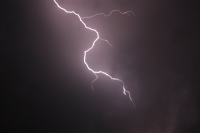
(Image; Lightning over Oklahoma on May 1, 2009. Credit: Sean Waugh/NOAA/NSSL, NOAA Photo Library).Heat lightning is one that really surprises people here in my neck of the woods. For years, people have been told by their grandmother or uncle that the heat of the day causes the sky to illuminate during the warm season. There is honestly no such thing as “heat lightning.” It is not some specific type of lighting. The use of the term heat lightning has evolved to describe lightning too far off in the distance to hear the thunder. Alternatively, it may also be used to refer to distant cloud-to-cloud or intracloud lightning. Remember, only about 20% of lightning is the cloud-to-ground type.
Polar vortex gained prominence in the last decade or so but has always been a part of meteorological textbooks and research papers. It is not an Arctic hurricane or distinct storm feature like a tornado. A Stanford University website describes the Polar Vortex this way - “The polar vortex forms every winter because of the temperature difference between the equator and the poles....A jet forms to balance this temperature difference. This jet is what we call the polar vortex or the polar night jet.” This feature is found about 6 miles above the surface of the Earth and generally flows completely around the Pole. Other planets can have one too.
(Image: large hailstones (next to a baseball) from a thunderstorm. Credit: NOAA Legacy Photo; OAR/ERL/Wave Propagation Laboratory/NOAA Photo Library)Hail is often misunderstood and we are now in the season (Spring) in which it ramps up in many locations. Over the years, many friends have messaged me during a winter weather event asking if they were seeing hail in their yard. They were actually describing “sleet” or ice pellets, which is often associated with wintry weather scenarios. By the way, don’t confuse sleet with freezing rain, which is precipitation that falls to the ground as liquid but then freezes because the temperature is below 32 degrees F. Hail is a form of frozen precipitation that forms in thunderstorms, which means that it can be found in Spring and Summer storm. For more on how hail forms, visit the outstanding National Weather Service Jet Stream website.
Marshall Shepherd Dr. J. Marshall Shepherd, a leading international expert in weather and climate, was the 2013 President of American Meteorological Society (AMS) and is Director of the University of Georgia’s (UGA) Atmospheric Sciences Program. Dr. Shepherd is the Georgia Athletic Association Distinguished Professor and hosts The Weather Channel’s Weather Geeks Podcast, which can be found at all podcast outlets.


No comments:
Post a Comment