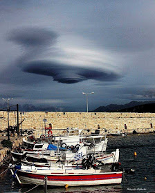
 As a meteorologist it's easy to see how some people who are not could mistake a Lenticular cloud for a UFO. So, today's blog gives you an explanation of what they are with a photo so you can know what they look like.
Photo right: This image came from Greece: Beautiful lenticular cloud over Rethymnon, Crete, Greece on Jan 11, 2018 Photo: Giannis Gkikas / Cyclone of Rhodes
WHAT ARE LENTICULAR CLOUDS? In Latin they are called Altocumulus lenticularis.
They're stationary clouds that form in the troposphere (lowest layer of the atmosphere), typically in perpendicular alignment to the wind direction. They look like a saucer!
THREE TYPES - There are three main types of lenticular clouds: altocumulus standing lenticular (ACSL), stratocumulus standing lenticular (SCSL), and cirrocumulus standing lenticular (CCSL), varying in altitude above the ground.
ALTITUDE: Up to 40,000 feet high
HOW THEY FORM - A lenticular cloud normally develops on the downwind side of a mountain or mountain range. It forms when stable, moist air flows over a mountain, creating a series of oscillating waves in the atmosphere.
If the temperature at the top (crest) of the wave equals the dewpoint temperature, condensation occurs in a lens formation. As the air falls down the trough of the wave, where the temperature and dew point temperature are not equal, evaporation occurs. Thus, a wave cloud, or a series of lenticular clouds, is capable of forming.
Here's a VIDEO from the Weather Channel to explain how they form:
https://youtu.be/u7CVY1vLXcY

No comments:
Post a Comment